


You are viewing a single thread.
View all comments 2 points
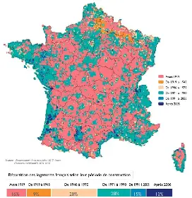
1946-1970 appears to be high density housing. 20% and just small squares peppered around urban centers.
2 points
1946-1970 appears to be high density housing. 20% and just small squares peppered around urban centers.
For the map enthused!
Rules:
post relevant content: interesting, informative, and/or pretty maps
be nice
2.2K
Monthly active users
340
Posts
4K
Comments